")
")
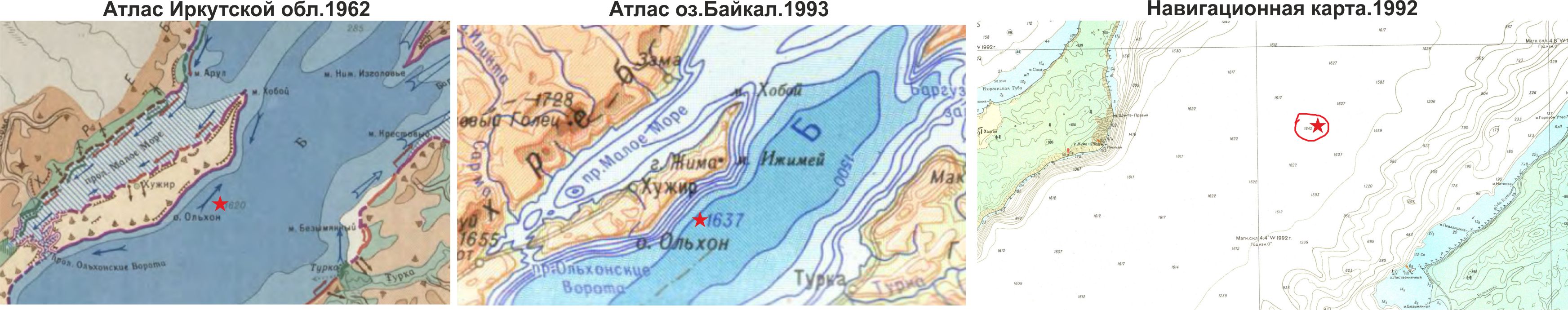
More on the maximum depth of Lake Baikal
The maximum depth of Lake Baikal increases as it is studied. Thus, in 1798, one of 28 depth measurements showed a depth of 1238 meters between the Angara River and the Selenga River Delta. In the 1962 edition of the Atlas of Irkutsk region, the deepest point recorded is 1620 meters. This location was in the Middle Basin, about 10-12 km south of Cape Izhimey, Olkhon Island. Then, on July 28, 1991, during the “Pises” dive, a new maximum depth of 1637 meters was recorded. These data are included in the Atlas of Lake Baikal, published in 1993.
From 1979 to 1986, the Department of Navigation and Oceanography of the Ministry of Defense of the Soviet Union conducted bathymetric survey of Lake Baikal. The work was carried out both from ships and by shore teams to ensure accurate geodetic positioning of the hydroacoustic profiles. During this work, the depth of Lake Baikal was measured at 1642 meters. While the depths of 1620 and 1637 meters were found in approximately the same zone (to the south of Cape Izhimey), the depth of 1642 meters was discovered directly opposite this cape. The cartographic materials from the expeditions of the Ministry of Defense of the USSR were published in 1992 and had a stamp for official use. The data were declassified only in 1999.
Thus, at the time when the maximum depth of 1637 meters was recorded in 1991, only the Ministry of Defense of the USSR had information about a depth of 1642 meters, and this data had not been published at that time. Now, the depth of 1642 meters is undisputed, and it is recommended to adhere to these data.