")
")
The expedition on R/V Akademik V.A. Koptug will take place on September 16-29, 2025
The purpose of expedition: Interdisciplinary study of the current state of the coastal zone of Lake Baikal, focusing on the long-term dynamics and shifts in the dominant species of hydrobionts, as well as the factors influencing them, in the context of large-scale negative ecological processes occurring in the lake.
The tasks of expedition:
- Collection of material for the establishment of long-term observation series on the dynamics of biomass and species composition of macroalgae (including cyanobacteria) in the shallow water zone, with a focus on the distribution of alien filamentous species in seasonal and interannual aspects;
- Sampling for the study of the fauna composition of ostracods, bathynellids, harpacticoids, and microturbellarians in the coastal zone of Lake Baikal;
- Sampling to assess the condition of phytoplankton in the coastal zone of Lake Baikal;
- Collection of data on coastal plant emissions (CPE) in areas of their mass accumulation, serving as an indirect indicator of the productivity of the phytobenthos in the coastal zone;
- Collection of microbiological samples to assess water quality in the coastal waters of Lake Baikal, as well as interstitial samples for the presence of sanitary indicator microorganisms, and the collection of samples for molecular biological analysis at the mouths of the following rivers: Bolshaya Cheremshanka, Malaya Cheremshanka, Pokhabikha, Tyya, and Ledyanaya;
- Collection of data for the study of the spatial distribution and temporal dynamics of the chemical composition components of water in interstitial and adjacent waters of the coastal zone of Lake Baikal (including the swash zone); sampling of hydrochemical samples in certain tributaries of the lake along the eastern shore.
Staff of expeditionary team: O.A. Timoshkin, D.Bi.Sci. (head of the team), V.V. Malnik, Cand.Bi.Sci. (deputy head of the team), M.I. Gula (leading engineer), A.E. Poberezhnaya (chief specialist), Krivorotkin R.S. (PhD Candidate), Alekseeva Т.М. (PhD Candidate), Eletstaya Е.V.(JRF), Yurgin R.A. (technician), Kudelin S.D. (technician), Sorokovikov S.A. (a second-year student of the Biological and Soil Sciences Faculty at Irkutsk State University).
Titles and registration numbers of the plans for research projects, for which the expedition was conducted:
“Comprehensive studies of the coastal zone of Lake Baikal: long-term dynamics of communities influenced by various ecological factors and biodiversity; causes and consequences of negative ecological processes”, №0279-2021-0007 (121032300180-7);
“Study of the role of atmospheric precipitation on aquatic and terrestrial ecosystems of the Lake Baikal basin, identification of sources of atmospheric pollution”, №0279-2021-0014 (121032300199-9);
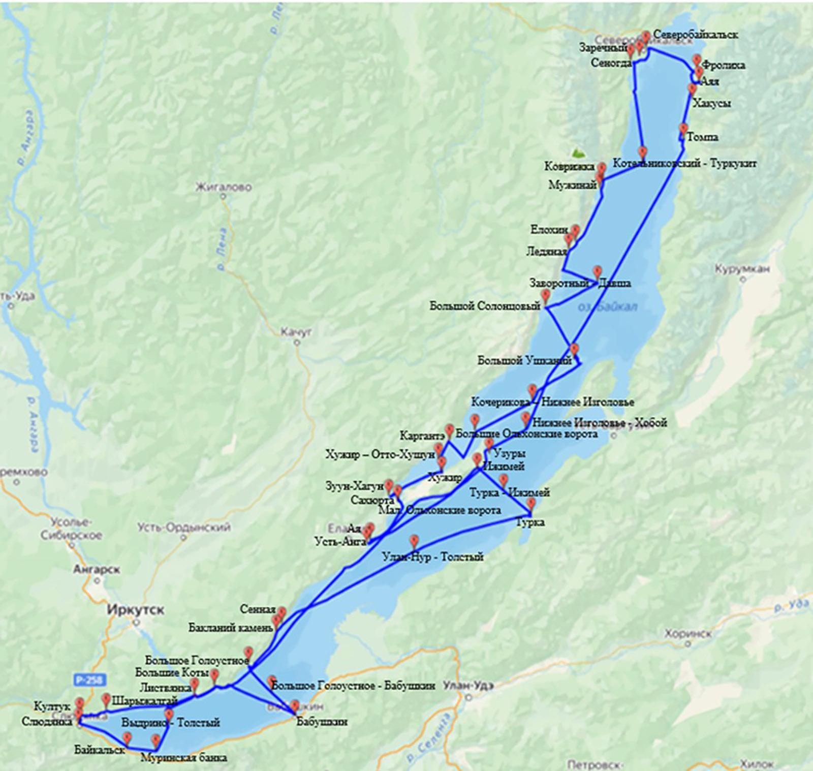
List and coordinates of specific sampling stations:
- Listvyanka settlement: N51°50′43.4″ E104°52′30.9″
- Sharyzhalgai settlement: N51°44′55.1″ E103°58′58″
- Angasolskaia Gulf: N51°43′51.9″, E103°49′38.4″
- Kultuk settlement:N51°43′24.3″ E103°43′11.2″
- Slyudyanka town: N51°40′00.9″ E103°43′04.6″
- Baikalsk town: N51°31′19.4″ E104°11′28.6″
- Murinskaya Bank: N51°30′06.5″, E104°28′55.1″
- Section Cape Tolstyi – Vydrino village: N51°39′27.8″ E104°36′4.3″
- Bolshye Koty settlement: N51°54′01.6″ E105°03′52.2″
- Section Bolshoye Goloustnoe settlement – Babushkin town: N51°49′6.7″ E105°31′54.4″
- Babushkin town: N51°43′13.5″ E105°51′58.2″
- Bolshoye Goloustnoe settlement: N52°01′36.8″ E105°24′14.4″
- The island of Baklaniy Kamen: N52°14′13.2″, E105°40′44.9″
- Sennaya Gulf (close to Peschanaya Bay): N52°16′58.5″, E105°44′07.9″
- Section Cape Ulan-Nur – Cape Tolstyi: N52°43′15.4″ E107°03′5.3″
- Turka village: N52°57′12.2″ E108°12′32″
- Section Turka Village – Cape Izhimei: N53°05′4.7″ E107°56′26.3″
- Cape Izhimei: N53°13′28.1″ E107°41′04.7″
- Aya Bay: N52°47′14.4″ E106°36′12.5″
- Ust-Anga: N52°46′38.9″, E106°34′27.3″
- The Malye Olkhonskiye Vorota (Olkhon Gate) Strait: N53°00′12.5″ E106°55′19.4″
- Sakhyurta settlement: N53°01′05.8″ E106°53′13.6″
- Zuun-Khagun Bay: N53°02′47.7″ E106°48′20.7″
- Khuzhir settlement: N53°11′32.5″ E107°19′46.8″
- Section Khuzhir settlement – Cape Otto-Khushun: N53°15′59.3″ E107°17′42.8″
- Kargante bay: N53°22′57.6″ E107°23′05.7″
- Nyurganskaya Bay: N53°17’10.8” E107°32’50.4”
- The Bolshye Olkhonskiye Vorota (Olkhon Gate) Strait: N53°26′19.1″ E107°39′57.4″
- Section Cape Kocherikova – Cape Nizhnee Izgolovye: N53°37′2.1″ E108°14′8.1″
- Bolshoy Ushkaniy Island: N53°51′06.3″ E108°39′18.2″
- Cape Bolshoy Solontsovyi: N54°10′14.3″ E108°22′13.1″
- Section Cape Zavorotnyi – Davsha Bay: N54°18′23.8″ E108°52′42.4″
- Ledyanaya River: N54°29′50.8″ E108°35′48.4″
- Cape Elokhin: N54°32′36.8″ E108°39′34.7″
- Cape Muzhinai: N54°50’48.4” E108°52’39.4”
- Cape Kovrizhka: N54°54′03.9″, E108°55′27.5″
- Section Cape Kotelnikovsky – Turkukit Bay: N55°00′3.6″ E109°19′48.8″
- Senogda Bay: N55°34′32.6″ E109°13′41.3″
- Zarechnyi settlememt: N55°35′40.1″ E109°17′50.9″
- Severobaikalsk town, Tyya River: N55°37’04.0’’ E109°19’12.1’’
- Frolikha Bay: 55°30′46.0″ E 109°52′10.0″
- Aya Bay: N 55°27′16.4″ E 109°54′06.4″
- Khakusy Bay: N55°22′13.1″, E109°47′02.6″
- Tompa Bay: N55°07′52.5″ E109°43′48.9″
- Section Cape Nizhnee Izgolovye – Cape Khoboi: N53°27′6.8″ E108°10′4.7″
- Uzury settlement: N53°19′34.6″ E107°45′35.9″
Preliminary scientific results:
1. Phytobenthos with a focus on the distribution of filamentous Spirogyra (Timoshkin O.A., D.Bi.Sci. (primary responsible), Yurgin R. (responsible), Gula M.I., Poberezhnaya A.E., Cand. B.Sci., Kudelin S.D. (responsible for sampling), Alekseeva T.A., Krivorotkin R.).
Sampling was conducted at depths ranging from the waterline to 1.5–2 m (waterline – 0.5 m – 1.5 m) on rocky soil using the stone units method (230 samples from individual stones); at depths from 1.7–2 m to 20 m, samples were collected using nets and scrapers (58 samples); additionally, 4 samples of free-floating spirogyra “rolls” (Fig. 3) were gathered from a sandy bottom. We took into account all stations where live filaments of the genus Spirogyra were encountered, regardless of their frequency of occurrence. Out of 230 samples collected from rocky soil with varying frequencies of occurrence, Spirogyra was found in 143 samples (62.2% of the total number of samples from rocky soil). Out of 58 samples (nets and scrapers) collected from depths more than 2 meters (soil types: sand, stones), spirogyra of various morphotypes were found in 40 samples (70% of the total number of samples collected using this method). When summing all types of sampling and their quantities (230+58+4=292), spirogyra was recorded in 186 samples (63.4% of their total number). Filamentous Spirogyra, not typical for open Lake Baikal, was not detected at three stations: in Kargante bays (western coast of Maloye More), Peshcherka (Bol. Ushkaniy Island) and B. Severnaya (Bol. Ushkaniy Island) among 37 stations examined in this regard (just over 8% of their total number).


Unfortunately, the number of stations, where “rolls” of filaments were found (mainly consisting of several morphotypes of spirogyres and edogoniums non-native to Lake Baikal) increased (Fig. 3), serve as an indirect indicator of hyperproduction of these algae.
The highest concentrations of non-native filamentous algae were detected at the following stations: the settlement of Sharazhelgay, Kultuk, Bolshye Koty (including 150 meters south of the mouth of the Bol. Kotinka River), near the settlement Babushkin (even at a distance of 500–1000 meters from the shore, at a depth of approximately 6 meters!), as well as opposite the settlement of Bol. Goloustnoe, Turka, and opposite the settlement Zarechnoe; in the bays of Frolikha and Ayaya. A relatively high frequency of Spirogyra occurrence was noted in samples collected at stations opposite the BPPM (Baikalsk), the sealarium (Listvyanka settlement), and also at Cape Elokhin. We regret to state the facts that single spirogyra filaments were found in phytocenoses on Cape Bol. Solontsovyi (Fig. 2); and also - quite numerous filaments - on Cape Izhimei (depth 2 m) (Fig. 4). Both stations were previously regarded as model ones in this regard, free from Spirogyra. The primary general conclusion is that the expansion of non-native Spirogyra and their widespread proliferation in the phytobenthos of the coastal zone of Baikal is ongoing and even advancing.
2. Meyozoobenthos (responsible - Alekseeva Т.А., KrivorotkinR.).
For further morphological and molecular-biological analyses of microturbellaria, ostracod, harpacticoid and batinellide, 94 samples were collected at 33 stations. We found representatives of most of the Baikal genera of these groups. We have discovered representatives of new species of ostracods of the genus Cytherissa (Sars, 1925).
3. Phytoplankton (responsible – Bondarenko N.A., D.B.Sci., responsible for sampling - Poberezhnaya А.Е., Cand. B.Sci.).
In September 2025, a total of 40 phytoplankton samples were collected. This month marks the transition from the peak of summer phytoplankton growth to the onset of autumn vegetation. It is widely recognized that the autumn peak in the proliferation of planktonic algae in Lake Baikal is less pronounced than that observed in spring. In recent years, nanoplankton phytoflagellates made the most significant contribution to primary production. According to the analyzed samples, the scenario in 2025 was similar: the highest abundance in the coastal zone of the lake was observed in cryptophytic and dinophytic algae; whereas in the pelagic zone, haptophytic and cryptophytic algae were predominant. The filamentous forms of algae were represented by minor concentrations of diatomaceous Asterionella formosa and green Monoraphidium contortum. . In the southern basin, the total biomass ranged from 30-160 mg/m ³, in the middle of the lake the indicators were higher - 70-220 mg/m ³. The range of fluctuations in the total phytoplankton biomass for the northern basin of Lake Baikal was 100-150 mg/m ³.
In the Maloye More Strait, the scenario was different. In this location, in early September, the vegetation of cyanoprocariotes and diatoms continued. The maximum biomasses observed were significantly higher, ranging from 1.29 to 2.70 g/m³ in Mukhor Bay. Additionally, the waters surrounding the bay exhibited considerable biomasses, reaching up to 2.57 g/m³. Phytoplankton was limited in the open pelagic zone of the strait and was represented mainly by cryptophytic and dinophytic algae. In the third decade of September, quantitative indicators of the abundance of plankton algae in the coastal zone of the strait sharply decreased to 100-200 mg/m ³, in the pelagic zone they remained at the same level. Nanoplankton phytoflagellates were the predominant organisms in the lake, serving as indicators of organic water pollution. This pollution arises from the mortality of rapidly proliferating plankton and benthic hydrobionts, a phenomenon referred to as “secondary pollution”.
4. Coastal accumulations of detritus (CAD) (responsible for sampling and preliminary report – Alekseeva Т.А., Krivorotkin R.; responsible – Nepokrytykh A.V., Cand.B.Sci., Timoshkin O.A., D.B.Sci.).
Coastal accumulations of detritus were found at 9 stations out of 28 surveyed (Fig. 5). CADs were found at Kultuk, Babushkin, Aya, Sakhyurta, Khuzhir, Bolshoy Ushkaniy (Severnaya Bay), Senogda, Zarechnoye, Frolikha stations. The most massive accumulations were found at the stations Zarechnoye, Bolshoi Ushkaniy (Severnaya Bay), Aya, Kultuk. Twenty-four samples were collected to study CADs; quantitative characteristics and composition of the detected CADs will be analyzed in the laboratory.

5. Assessment of water quality by sanitary-microbiological indicators (responsible - Malnik V.V., Cand.B.SCi).
Samples were collected at 34 stations located near the coastal area of Lake Baikal, all three basins, based on specified sampling points. In total, 125 samples were collected, which comprised 10 river samples, 62 surface samples from Baikal, 28 bottom samples from Baikal, and 25 interstitial samples. According to the established standards, the concentrations of E. coli and fecal enterococci in waters used for recreational purposes should not exceed 100 and 10 CFC/100 ml, respectively (SanPin, 1.2.3685-21). According to the research results, 6 out of 10 river samples (60% hereinafter - the share of the total), 8 out of 62 surface Baikal samples (about 13%) and 1 out of 28 bottom Baikal samples (4%) did not meet the established standards. Significant excesses in E. coli and enterococci were recorded at the following sites: 1) Pokhabikha River – surface (28 m below the waste water discharge pipe): 1030 and 1100 CFC/100 mL, respectively; 2) Pokhabikha River - surface (mouth, approximately 500 m downstream of the discharge pipe): 1050 and 500 CFC/100 mL, respectively; 3) Lake Baikal, Slyudyanka, 10 m from the mouth of the river. Pokhabikha - bottom: 2500 and 600 CFC/100 mL, respectively; 4) Bolshye Koty settlement (Gammarus station) - surface, (1 m from the water edge, first sample): 21 and 520 CFC/100 mL, respectively; 5) Bolshye Koty settlement (Gammarus station) – surface (1 m from the water edge, second sample, approximately 30 m from the first): 1 and 198 CFC/100 mL, respectively. Insignificant excess in the number of enterococci was noted at the mouths of the Bolshaya and Malaya Cheremshanka Rivers (near Listvyanka settlement), in the Baikal surface water, 1 m from the water edge in Aya Bay, in the Baikal surface water near Zarechny settlement.
Water samples from the rivers (Tyya, Ledyanaya, Mal. and Bol. Cheremshanka, Pokhabikha) were collected to extract DNA, aiming to identify the source of pollution in these waterways, whether it originates from human or animal activities, utilizing molecular genetic markers.
6. Hydrochemical studies (responsible – Tomberg I.V., responsible for sampling and preliminary report and sample analyses - Eletskaya Е.)
In total, during the expedition, hydrochemical studies were carried out at 25 stations along the entire perimeter of the lake, where 129 samples were collected. The temperature of the coastal water of Lake Baikal during the study period ranged from 8.5 (Cape Elokhin) to 16.8 °C (Uzury settlement). The electrical conductivity of the interstitial water along the coasts exhibited considerable variation. The highest measurements were observed in the wells located near Zarechnoye settlement (568.8 μS/cm) and Kultuk settlement (445 μS/cm), while the lowest value was recorded at Nyurgansky Cape (112.9 μS/cm). The electrical conductivity of water on the water edge was mainly close to the Baikal values: from 118.7 (Babushkin settlement) to 129.8 μS/cm (Slyudyanka town). The conductivity of the samples opposite Baikalsk was slightly higher (158.5 μS/cm). Dissolved oxygen content in interstitial water in September varied from trace values (Kultuk, Zuun-Khagun, Zarechnoye and Babushkin settlements) to 11.13 mg/dm ³. In the coastal water of the lake, oxygen concentrations ranged from 8.26 to 12.72 mg/dm ³. High phosphate content was noted in the interstitial water of the coasts opposite Zarechnoye (547 μgR/dm ³) and Kultuk (136 μgR/dm ³), Zuun-Khagun settlements (78 μgR/dm ³); maximum nitrate concentrations were recorded in opposite Kultuk settlement (50 mg/dm ³) and Ayaya Bay (17 mg/dm ³). In the coastal water of the lake, phosphate concentrations did not exceed 40 μgP/dm ³, and nitrates generally ranged from 0.04 to 0.20 mg/dm ³. Higher nitrate concentrations were observed in the coastal water opposite Slyudyanka (0.45 mg/dm ³) and Cape Elokhin (0.39 mg/dm ³). The processing of the material collected during the expedition continues in the laboratory of the Institute and the materials received will be presented in the report on the state assignment.