")
")
Expedition on R/V Akademik Koptyug on September 10-24, 2024
The purpose of the expedition: : Interdisciplinary study of the current state of the coastal zone of Lake Baikal in September 2024 from the perspective of long-term dynamics and change of complexes of dominant species of aquatic organisms, as well as their determining factors, in conditions of large-scale negative environmental processes in the lake.
Financing:within the State Assignment “Comprehensive studies of the Lake Baikal coastal zone: long-term dynamics of communities under the influence of various environmental factors and biodiversity; causes and consequences of negative environmental processes” (0279-2021-0007) (led by O.A. Timoshkin), salaries of Ph.D. (Biology) Kulikova N.N. and graduate student E.V. Yeletskaya – within the State Assignment “From the cell to the ecosystem: Investigation of the ultrastructure of hydrobionts and their communities in the evolutionary and ecological aspect by methods of cell biology and genomics” (0279-2021-0008) (led by Ye.V. Likhoshway) and “Study of the role of atmospheric precipitation on aquatic and terrestrial ecosystems of the Lake Baikal basin, identification of sources of atmospheric pollution” (0279-2021-0014) (led by Khodzher T.V.).
A total of samples collected:
Timoshkin Oleg Anatolyevich - chief researcher, Laboratory of Aquatic Invertebrate Biology, head of the team; Malnik Valery Vasilievich - researcher; Aleksandra Evgenievna Poberezhnaya - main specialist; Gula Marina Innokentyevna - lead. ing. laboratory assistant; Krivorotkin Roman Sergeevich - junior reasecher of laboratory; Alekseeva Tatyana Mikhailovna - junior reasercher; Kudelin Sergey Dmitrievich - technician; Igor Alekseevich Butusin - technician; Tomberg Irina Viktorovna - senior researcher; Yeletskaya Elena Vladimirovna - junior reasercher at Laboratory of ydrochemistry and atmospheric chemistry; Kulikova Natalya Nikolaevna - senior researcher at Laboratory of Biogeochemistry; Krasnova Milena Igorevna and Plotnikova Anastasia - 3rd year students of Biological and Soil Department of FSBEI HE “ISU”.
Observation zones:
- cape Sharyzhalgai: N 51°45'01.1'' E 103°59'01.3''
- town Baikalsk: N 51°31'19.4" E 104°11'28.6"
- town Slyudyanka: N 51°40'00.9" E 103°43'04.6"
- settlement Kultuk N 51°43'24.3" E 103°43'11.2"
- cape Tolsty – Snezhnaya river: N 51º45'05.4" E 104º43'14.2''
- Listvyanka settlement: N 51°50'43.4'' E 104°52'30.9''
- Bolshye Koty settlement: N 51°54'01.6" E 105°03'52.2''
- Bolshoe Goloustnoe settlement: N 52°01'36.8" E 105°24'14.4"
- To the north of cape Bolshye Khomuty: N 52°11'25.0'' E 105°38'57.5''
- Cape Zolotoi Utes: N 52°18'04.4" E 105°45'22.2"
- Cape Krasny Yar: N 52°24'33.7'' E 105°52'20.2''
- Ust-Anga Bay: N 52°46'31.4'' E 106°34'48.1''
- Aya bay: N 52°47'14.4" E 106°36'12.5"
- Malye Olkhonskye Vorota strait: N 53°01'12.5'' E 106°54'52.4''
- Sakhyurta settlement: N 53°01'05.8" E 106°53'13.6"
- Zagli bay: N 53°02'15.4'' E 106°56'57.0''
- Khytyrkhei, Khul bay: N 53°03'08.5" E 106°55'48.1"
- Shida bay: N 53°03'13.1" E 106°47'02.9"
- Kurkutskaya bay (Radost bay 3): N 53°01'47.0" E 106°50'43.7"
- Mukhur-Khale bay: N 53°09'04.6" E 106°55'00.5"
- Semisosenny bay: N 53°06'45.7" E 107°04'10.9"
- Zamogoi Island: N 53°10'27.7'' E 107°06'21.1''
- Oto-Khushun cape: N 53°19'36.3" E 107°16'50.3"
- Section Khuzhir settlement – Yadyrtui cape: N 53°14'08.4'' E 107°13'32.8''
- Khuzhir settlement: N 53°11'32.5" E 107°19'46.8"
- Ulan-Khan cape: N 53°16'29.2" E 107°06'57.6"
- Nyurgon bay: N 53°16'37.0" E 107°32'19.9"
- Kargante bay: N 53°22'57.6" E 107°23'05.7"
- Zama cape: N 53°25'43.1" E 107°30'32.3"
- Bolshye Olkhonskye Vorota strait: N 53°26'27.7" E 107°39'30.4"
- Uzury settlement:: N 53°19'34.6" E 107°45'35.9"
- Ushkany islands: N 53°51'06.3" E 108°39'18.2"
- Bolshoi Solontsovyi cape: N 54°10'14.3" E 108°22'13.1"
- Sredny Kedrovy cape: N 54°23'14.3" E 108°31'14.7"
- Elokhin cape: N 54°32'36.8" E 108°39'34.7"
- Senogda bay: N 55°34'37.0" E 109°13'34.7"
- Zarechny settlement: N 55°35'40.1" E 109°17'50.9"
- Severobaikalsk town: N 55°38'52.5" E 109°23'04.6"
- Dagarskaya bay: N 55°39'16.1'' E 109°54'08.1''
- Frolikha bay: N 55°30'46.0" E 109°52'10.0"
- Ayaya bay: N 55°27'16.4" E 109°54'06.4"
- Khatusy bay: N 55°21'37.5" E 109°54'53.3"
- Tompa settlement: N 55°07'52.5" E 109°43'48.9"
- Turkukit town – Kotelnikovsky cape: N 54°58'43.9" E 109°25'15.2"
- Davsha bay: N 54°20'47.9" E 109°28'49.6"
- Section Davsha bay – Zavorotny cape: N54°20'30.7" E109°19'24.2"
- Svatoy Nos, to the north of cape Rytyi: N 53°37'07.4'' E 108°38'15.9"
- Maksimikha settlement: N 53°16'18.6" E 108°42'48.7"
- Section Krestovy cape – Izhimei cape: N53°16'52.8" E108°08'26.3"
- Izhimei cape: N 53°13'28.1" E 107°41'04.7"
- Section Orso cape – Tolsty cape: N52°47'03.1" E107°01'13.8"
- Babushkin town: N 51°43'13.5" E 105°51'58.2"
- section Babushkin town – Kadilny cape: N51°49'21.9" E105°29'18.1"
- to the south of cape Kadilny: N 51°54'44.7'' E 105°11'51.1''
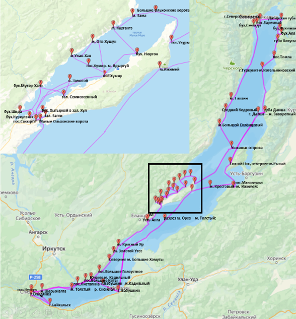
Index map of the expedition route (drawn by Kudelin S.D. and Gula M.I.):
Total number of samples collected:
Bacterial (sanitary-microbiological) – 153;
Phytoplankton – 36;
Phytobenthos, quantitative – 198;
Zoobenthos – 104;
Hydrochemical – 154;
Photos of the bottom (standard frame, quarter of square meter) – 1648;
Photos of lifted stones (stone units) – 594.
Preliminary scientific results:
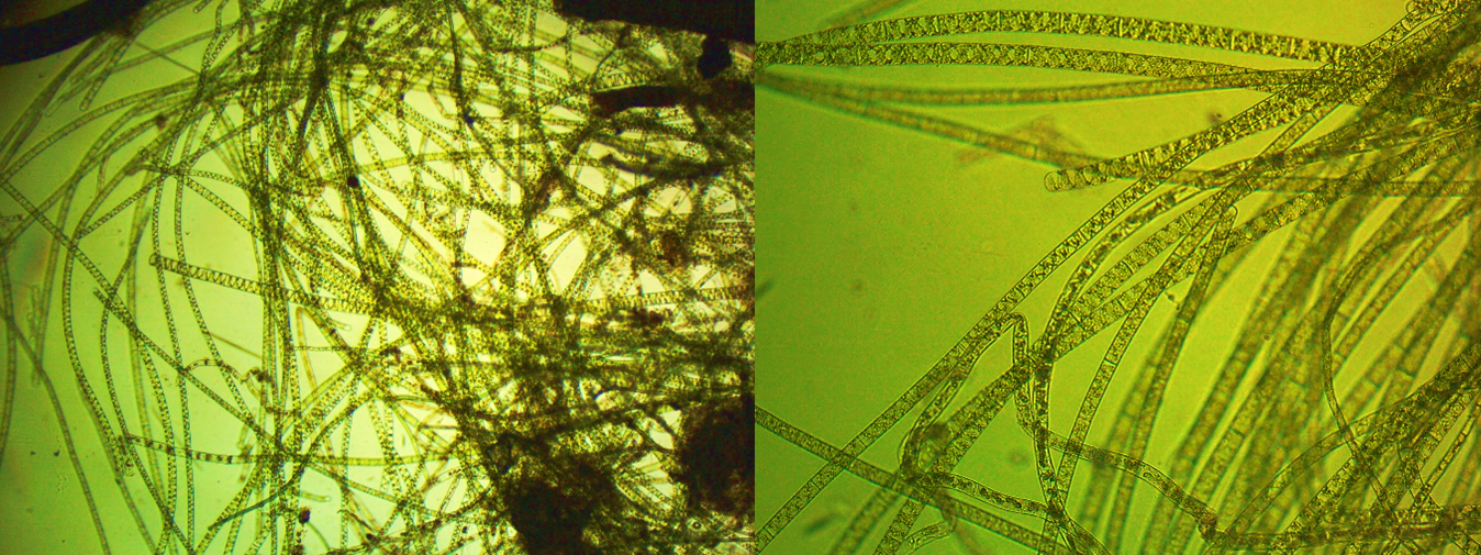
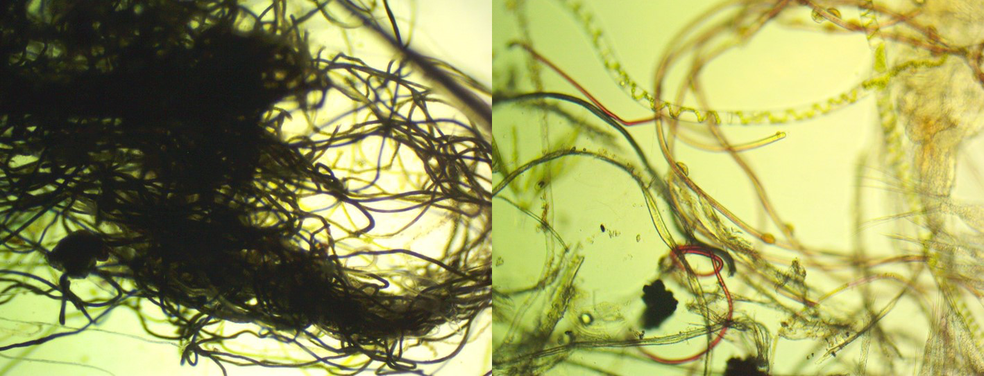
Phytobenthos (responsible - Timoshkin О.А.). At standard stations (about 50 - see index map), 242 qualitative and quantitative algae samples were taken using the stone-unit method (3 stones from the water`s edge, 0.5, 1.5-1.7 m). They were pretreated in vivo, their digital photographs were obtained and processed (about 4,800 in total), phytocomplexes and groups that dominated in the shallow zone in September 2024 were briefly characterized. The following crucial conclusions were made: 1) Similar to 2016 (a period characterized by numerous fires of the coastal forests of the lake, as well as in the area of the Baikal natural territory as a whole), almost along the entire perimeter of the shallow zone of Lake Baikal, there was a massive development of indigenous benthic cyanoprocariotes Tolypothrix distorta; in some areas, we again observed the phenomenon of “blue-green tides” with the dominance of torn tolipotrix thalli (see video, and also - Fig. 1).
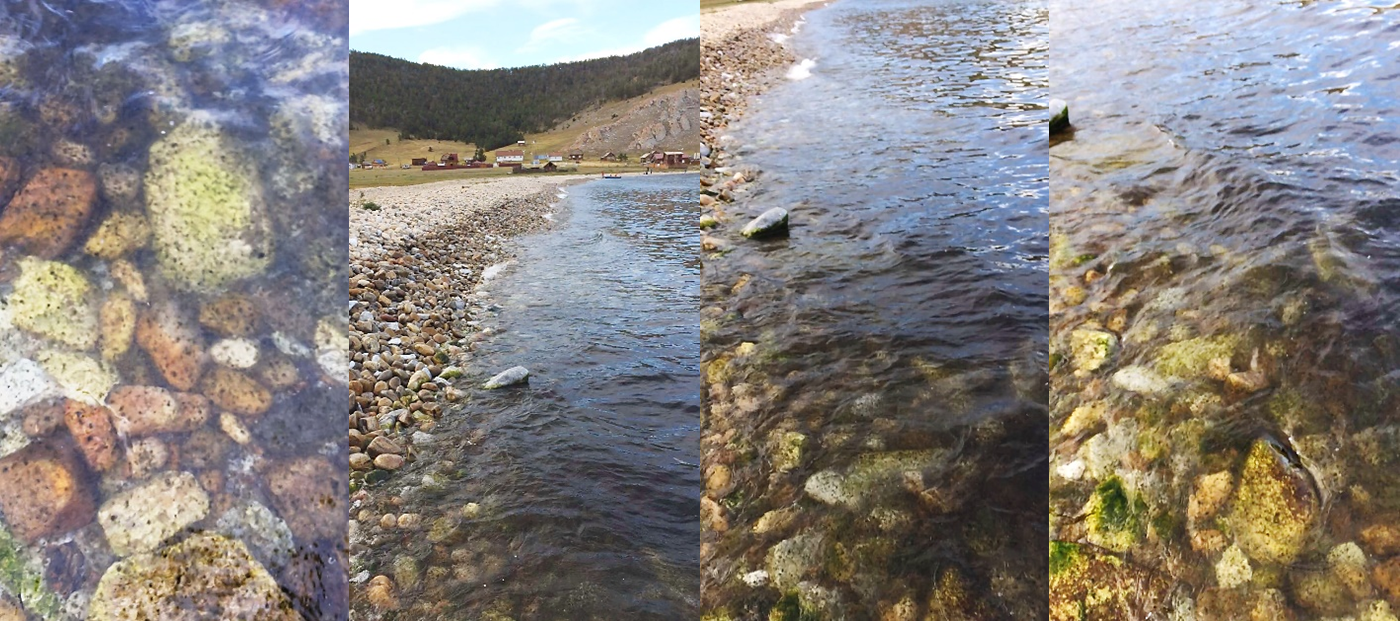
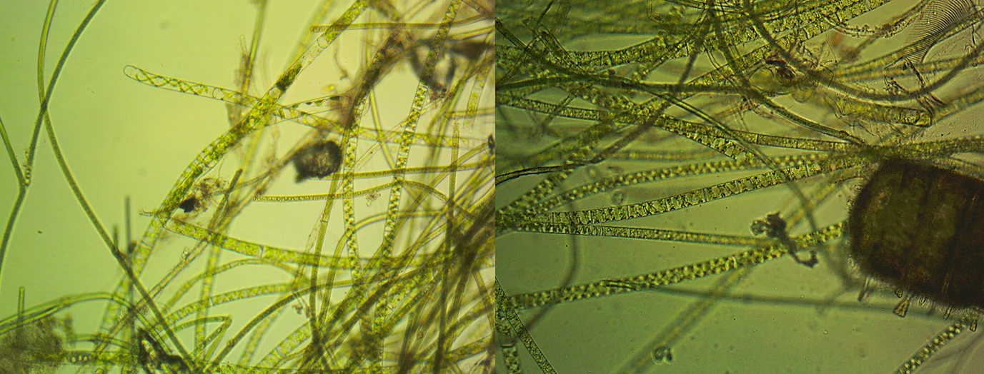
2) Based on the diversity and dominance of unusual filaments not typical to the lake (representatives of the genera Oedogonium, Spirogyra), the following zones of the lake have experienced the most significant changes in the structure and function of phytobenthos: opposite the settlements of Baikalsk, Slyudyanka, Kultuk, Sharyzhylgai (Tsarskoye Podvorie camp site), Listvyanka, Bol. Goloustnoye, Uzury, Aya, Khuzhir, Severobaikalsk, Frolikha, Ayaya, etc.; alien algae (especially spirogyra) are found in different quantities and at different depths in most of the studied sites. Some new places of mass blooming of several morphotypes of spirogyres and edogoniums have been discovered for our research, for example, rocky shallow water opposite the small settlement of Uzury (northeast coast of Olkhon Island). At depths of 1-5 m, in addition to cladophore, the phytocomplex of alien filaments dominated here (2-3 morphotypes of spirogyra, tolipotrix distorta, singly - edogoniums) (Fig. 2, 3). Second place - opposite the hotel complex “Tsarskoye Podvorye”, Sharyzhalgai settlement. Using this example, it was discovered that this phenomenon also has a certain spotting in the distribution and degree of development: in the southern part of the bay, opposite the hotel, there were no filaments; in the north - developed in mass from a depth of about 1-1.5 m (Spirogyra morphotype 1 dominated - an indicator of wastewater pollution, with a slight admixture of filaments of other morphotypes. 3) In samples collected from some sites of the shallow water zone of South Baikal (opposite the settlement of Slyudyanka, the settlement of Sharyzhalgai), filaments or an unusual type of “balls” of microplastic were often found (Fig. 4).
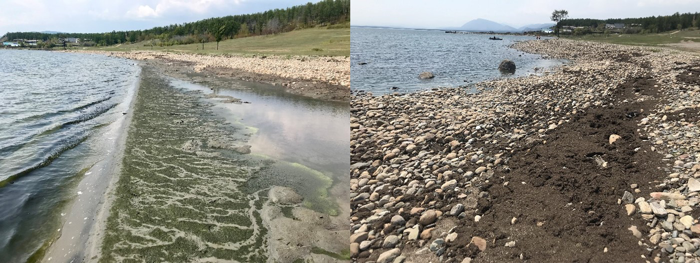
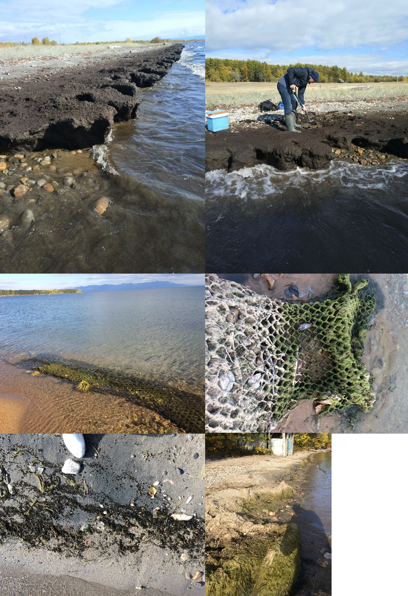
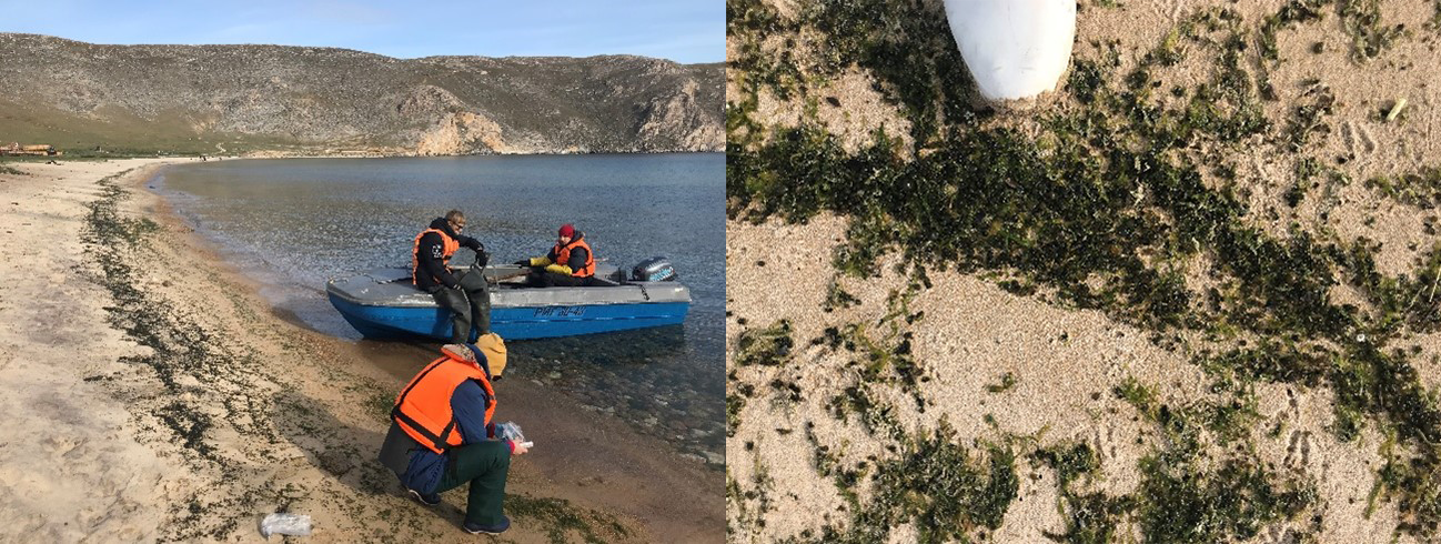
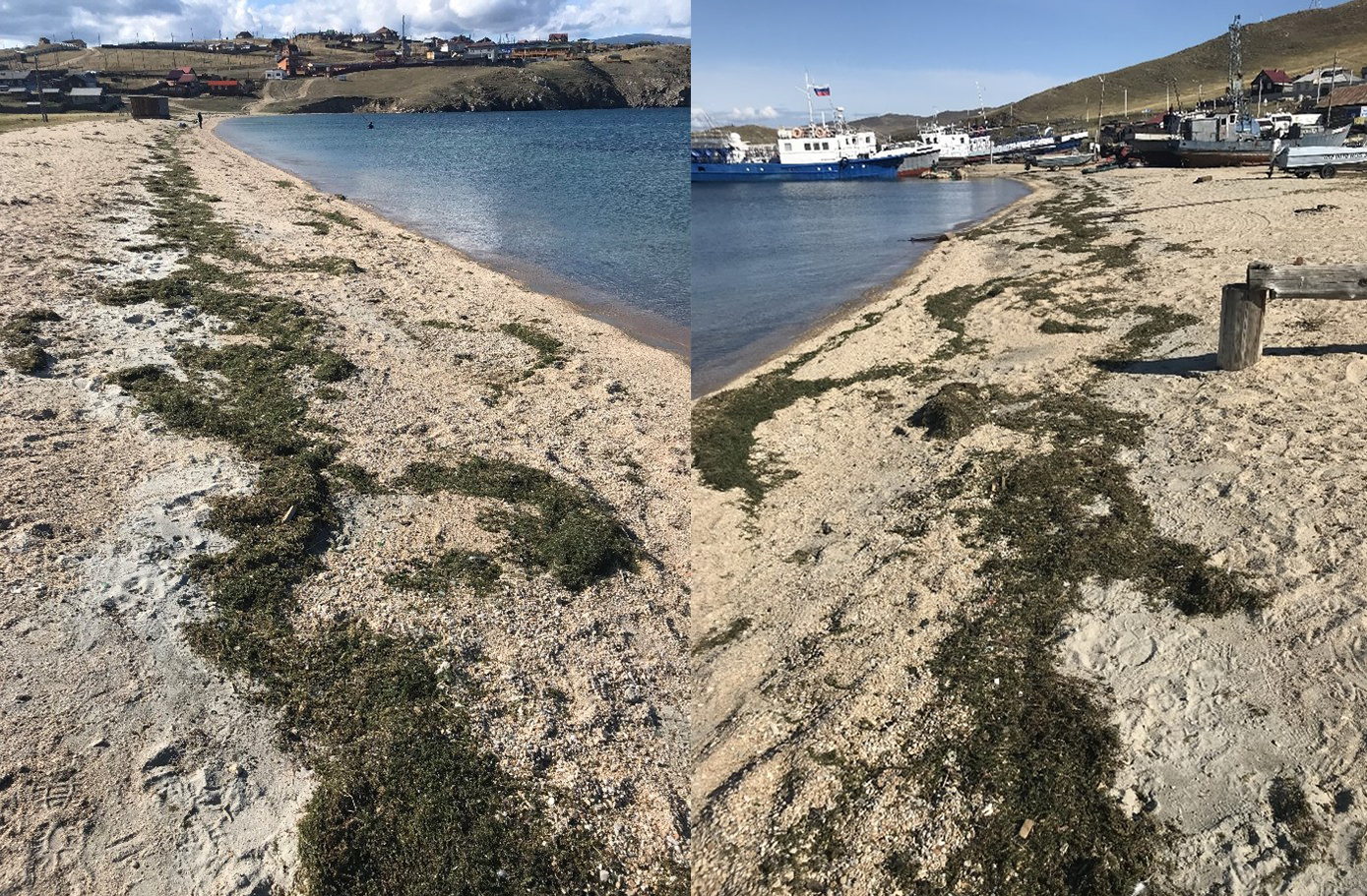
4) Coastal accumulations of plant detritus, primarily algae and macrophytes, were found in several locations. Significant accumulations of blue-green turf torn from the substrate, were found opposite Uzury settlement (Olkhon Island) (tolipotrix) (see video, Fig. 1); moreover, opposite Zarechny settlement (South Baikal) (spirogyres and vegetable detritus, Fig. 5); opposite Maksimikha settlement (Barguzinsky bay) (cladophora glomerata, representatives of higher aquatic plants, nostocs, Fig. 6); in Aya Bay (Middle Baikal) (with the dominance of draparnaldioids and nostocs, Fig. 7); opposite Sakhyurta settlement (South Baikal) (elodea, duckweed, other representatives of higher aquatic plants, nostocs, Fig. 8).
Sanitary-microbiological studies (responsible Malnik V.V.). During this Circum-Baikal expedition, 153 samples were taken for sanitary-microbiological analysis in three basins of the lake. Samples were taken according to the standard grid (Tomberg et al., 2012; Malnik et al., 2022). During studies in September 2024, 2 replicates were collected at each station (1 m below the edge) (except for Maloe More Strait, see below); at the same time, the distance between the sampling points was approximately 50 m. The bays of Maloe More strait in Middle Baikal were examined in details. In the standard points of Maloe More strait, which we have been examining since 2014, sampling was also carried out according to the standard grid (see above). The grid was a little modified at the remaining stations in the strait: samples were taken in one replicate, 1 m above the edge in the dug hole, and also from the water surface 1, 10 and 100 m below the water`s edge. In total, 54 samples were taken in the coastal zone, at 13 stations and three stations in the center of Maloe More strait.
Bacterial groups were detected and counted using the membrane filtration method on 0.45 μm nitrocellulose filters according to MUK 4.2.1884-04 and GOST 24849-2014. The number of thermotolerant E. coli was determined by membrane filtration using selective high-chromium agar (manufactured by Himedia No. M1571).
The presence of fecal enterococci was detected by membrane filtration using Slanetz and Bartley Medium nutrient selective agar (manufactured by Himedia No. M 612) and Bile Esculine Azide Agar (manufactured by Himedia No. M493).
According to the main regulatory document, in the waters of surface water bodies in recreation areas, as well as within populated areas during swimming, the number of E. coli and enterococci in the Russian Federation should not exceed 100 and 10 CFU/100 ml, respectively (Sanitary Rules and Norms 1.2.3685-21. Hygienic standards and requirements for ensuring the safety and (or) harmlessness to humans of environmental factors).
Sanitary-indicative bacteria were not found at three central points in Maloe More strait. At 1 m below the water`s edge in Kurkutskaya Bay, an excess of E. coli (109 CFU/100 ml) and enterococci was recorded almost 4 times (39 CFU/100 ml). In Shida Bay, the standards at a point 1 m below the water`s edge were exceeded for E. coli and enterococci by more than 3 and 12 times, respectively. It should be mentioned that it rained at these locations throughout the sample process, and turbidity of the coastal water was noticed along with waves in Shida Bay of 0.15 meters in height. Precipitation may therefore affect the quantity of FIBs in the lake`s near-river zone. In interstitial water, significant amounts of FIBs were found in Zagli Bay (E. coli - 6,400 CFU/100 ml, Enterococci - 6,900 CFU/100 ml) and Kurkutskaya Bay (E. coli - 930 CFU/100 ml, Enterococci - 1,170 CFU/100 ml).
Within three basins, excess in enterococci was observed in surface and bottom water at the following sampling stations: Kultuk settlement (1 m below the water`s edge at two points - 32 and 19 CFU/100 ml, respectively), Listvyanka settlement (1 m below the edge: 116 and 68 CFU/100 ml; on the surface 10 m below the water`s edge: 124 and 132 CFU/100 ml; on the surface 20 m below the water`s edge: 22 CFU/100 ml, in bottom water: 218 and 225 CFU/100 ml); Aya Bay (1 m below the water`s edge - 21 CFU/100 ml); Uzury settlement (1 m below the water`s edge - 12 CFU/100 ml), Bolshoi Ushkaniy Island (Pechsherka Bay) (1 m below the water`s edge - 19 CFU/100 ml), Senogda Bay (1 m below the water`s edge at two points 34 and 13 CFU/100 ml, respectively), Cape Izhimei (1 m below the water`s edge - 10 CFU/100 ml).
Significant concentrations of E. coli and enterococci in interstitial waters were noted in the following zones: Uzury settlement (2,330 and 2,500 CFU/100 ml, respectively), Cape Bolshoy Solontsovy (1,020 and 544 CFU/100 ml, respectively), Cape Elokhin (392 and 572 CFU/100 ml, respectively).
In general, the sanitary-bacteriological state of the waters of the coastal zone of the lake in September 2024 is assessed as stable at the examined sampling sites. There are some places to pay attention to: Listvyanka settlement, where the concentrations of enterococci at 6 studied points at a distance of up to 20 m from the coast exceeded the permissible standards. In Maloe More strait (Shida and Kurkutskaya bays), excess of permissible standards was also noted.
Hydrochemical studies (responsible Tomberg I.V.) were carried out at 34 stations along the entire perimeter of the lake, 154 samples were taken. The temperature of the coastal water of Lake Baikal remained quite high: in the south of the lake 9-15 °С, in the north 8-11 °С. The electrical conductivity of the interstitial water of the coasts varied widely. Maximum values were recorded in holes in Davsha settlement (661 uS/cm) and on Cape Mukhor-Khale (560 uS/cm), the minimum in Bolshye Koty settlement (114 uS/cm). The electrical conductivity of water on the water`s edge was basically close to the Baikal values - 118-124 uS/cm). Coastal water at stations of Baikalsk town, Kultuk settlement, Davsha settlement, Maksimikha settlement, Elokhin cape, and in Aya Bay showed a little higher electrical conductivity (128–142 uS/cm). The dissolved oxygen content in the interstitial water of the coastal holes in September varied from trace values (settlements of Kultuk, Uzury, Sakhyurta, Davsha, and the towns of Babushkin, Severobaikalsk) to 10.5 mg/dm3. In the coastal water of the lake, oxygen concentrations varied from 8.37 to 12.83 mg/dm3 (78-120% saturation). A high phosphate content was noted in interstitial water in Kultuk settlement (275 μg/ dm3), and significant nitrate concentrations of 4.75 μg/ dm3 were recorded here. In the area of Kultuk settlement, high concentrations of these components were also recorded in the coastal water of the lake: phosphates - 16 μg/dm3, nitrates - 2.99 mg/dm3. In other zones of the lake, phosphate concentrations in coastal water did not exceed 8 μg/ dm3, nitrate concentrations ranged from 0.04 to 0.018 mg/ dm3. We should note that the content of nitrogen and phosphorus compounds in interstitial water of Uzury settlement was high. Thus, maximum concentrations of ammonium ions (0.262 mg/ dm3), nitrites (0.149 mg/ dm3) and nitrates (5.98 mg/ dm3) were recorded here. Total nitrogen content in the hole exceeded 3.5 mg/ dm3, total phosphorus - 2 mg/ dm3.
Phytoplankton (responsible Bondarenko N.A.) In 2024, an analysis of late summer phytoplankton revealed that its size structure is still changing, with a greater share of small-sized fast-growing species (r strategists). Even in the pelagic zone, Maloye More Strait, and the northern basin of the lake, an intense vegetation of indicators of organic water pollution—cryptophytic algae of the genus Cryptomonas - was observed. This was caused by the presence of easily soluble organic matter, the primary source of which was decomposing colonies of cyanoprocariotes, which developed intensely in these waters during the summer and early September. Biomasses, due to the small size of the dominants, are insignificant: from 100-300 mg/m3.
Detailed processing and analysis of the material collected during the expedition will be continued in the laboratories of the Institute.
BRIEF CONCLUSIONS:
It was found out that the shallow-water zone (including the splash zone) of Uzury settlement on Olkhon Island turned out to be one of the polluted zones in almost all indicators - the abundance and mass of spirogyra, hyperproduction of cyanoprokaryotic tolipotrix (see video and Fig.1), hydrochemical and sanitary-microbiological indicators of interstitial water holes; there are fewer stations where alien filamentous alga have not yet been found (opposite Cape Bol. Solonetzovy, Izhimey, Ushkany Islands, the marine part of the Svyatoi Nos Peninsula). Negative environmental processes in rocky shallow water, namely changes in the structure and quantitative indicators of phytoplankton and phytobenthos, the formation of coastal accumulations of plant detritus at the extreme northern and southern ends of the lake, as well as opposite Maksimikha settlement, FIBs pollution, eutrophication of interstitial and coastal waters of zones located opposite settlements, etc., continue to progress.
The expedition research program has been completed in full.