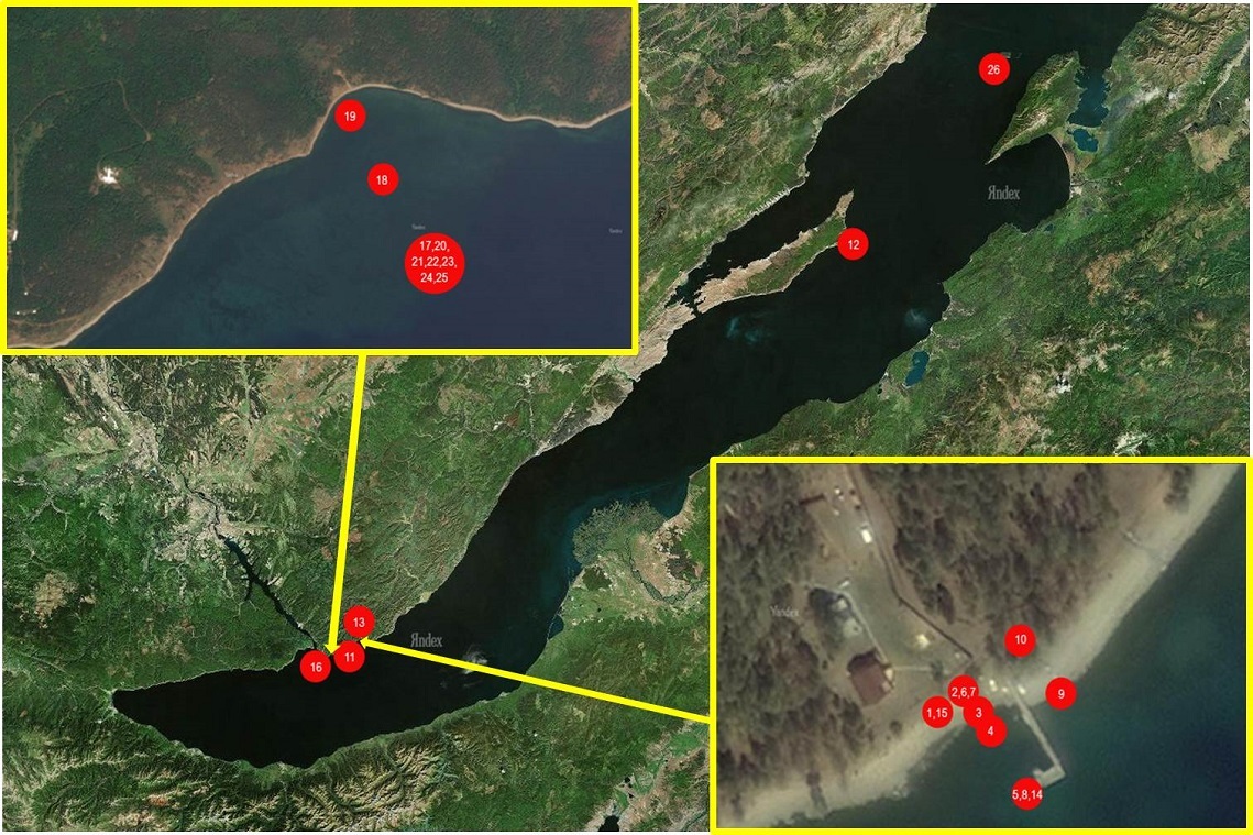
Stations
Showing {begin, number}-{end, number} of {totalCount, number} {totalCount, plural, one{item} other{items}}.
| # | Name | Description |
|---|---|---|
| 1 | BK-3m-bottom | Bolshye Koty Bay. Coastal zone. Bottom, about 3 m depth. |
| 2 | BK-3m-bottom(2) | Bolshye Koty Bay. Coastal zone. Bottom, about 3 m depth. Double (parallel) measurements by second logger |
| 3 | BK-3m-water_body | Bolshye Koty Bay. Coastal zone. Water column, about 3 m depth. |
| 4 | BK-above-shore_line-20cm | Bolshye Koty Bay. Splash zone. About 1 m above shore line, ca. 20 cm below the bottom surface |
| 5 | BK-above-shore_line-5cm | Bolshye Koty Bay. Splash zone. About 1 m above shore line, ca. 5 cm below the bottom surface |
| 6 | BK-above-shore_line-surface | Bolshye Koty Bay. Splash zone. About 1 m above shore line, bottom surface |
| 7 | BK-air | Bolshye Koty Bay. Air. |
| 8 | BK-air(2) | Bolshye Koty Bay. Air. Double (parallel) measurements by second logger |
| 9 | BK-below-shore_line | Bolshye Koty Bay. Coastal zone. About 1 m below shore line |
| 10 | BK-kotinka-stream | Bolshye Koty Bay. Bolshaya Kotinka River, right above the settlement’s border. |
| 11 | BK-shore_line | Bolshye Koty Bay. Coastal zone. Shore line. |
| 12 | BK-zhilishe-shore-line | Bolshye Koty Bay. Coastal zone. Shoreline near by Zhilische stream mouth |
| 13 | BK-zhilishe-stream | Bolshye Koty Bay. Zhilische stream. About 50 m above the stream mouth |
| 14 | Bol-Ushk | Bolshoy Ushkany Island, bottom. 3 m depth |
| 15 | BRZ -0.5 | Berezovy ecological test site. Station 0.5. Coastal zone, bottom. 0.5 m depth, about 50 m from the shore line |
| 16 | BRZ -2.9 | Berezovy ecological test site. Station 2.9. Coastal zone, bottom. 2.9-3 m depth, about 300 m from the shore line |
| 17 | BRZ -7.5 | Berezovy ecological test site. Station 7.5. Coastal zone, bottom, about 750 m from the shore line |
| 18 | BRZ -7.5-0.5 | Berezovy ecological test site. Station 7.5. Coastal zone, 0.5 m above the bottom, about 750 m from the shore line |
| 19 | BRZ -7.5-11.9 | Berezovy ecological test site. Station 7.5. Coastal zone, 11.9 m above the bottom, about 750 m from the shore line |
| 20 | BRZ -7.5-2.2 | Berezovy ecological test site. Station 7.5. Coastal zone, 2.2 m above the bottom, about 750 m from the shore line |
| 21 | BRZ -7.5-5.4 | Berezovy ecological test site. Station 7.5. Coastal zone, 5.4 m above the bottom, about 750 m from the shore line |
| 22 | BRZ -7.5-8.7 | Berezovy ecological test site. Station 7.5. Coastal zone, 8.7 m above the bottom, about 750 m from the shore line |
| 23 | BRZ-7.4 | Berezovy ecological test site. Station 7.4. Coastal zone, bottom. 5-6 m depth, about 750 m from the shore line |
| 24 | EM-3m-bottom | Emelyanikha Bay. Coastal zone. Bottom, about 3 m depth. |
| 25 | IZH-3m-bottom | Opposite of Izhimey Cape (Olkhon Island). Coastal zone. Bottom, about 3 m depth. |
| 26 | List-3m-bottom | Listvennichny Bay. Coastal zone. Harbor of Limnological Institute SD RAS (Karavanka). Bottom, about 3 m depth. |